This is a new service – your feedback will help us to improve it.

Registered title extent for Buckingham Palace

See which land is included in example title NGL815204.

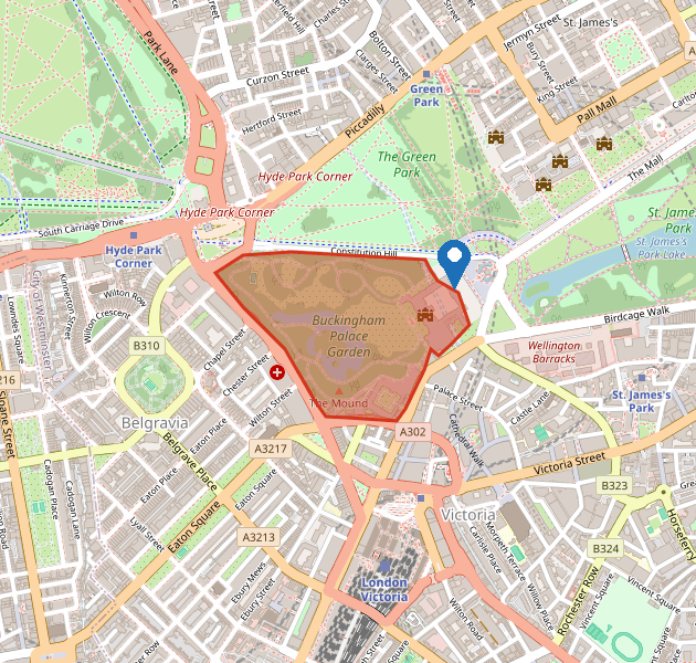
The red outline on this map is the geographic extent of the registered title: the palace, the east forecourt and the private gardens. Use the key on the map to see what the red area means.

Example title

This map shows the land in example title NGL815204, Buckingham Palace.

The red outline is the registered extent: the palace buildings, the east forecourt and the private gardens. It is not an official copy of the title plan. HM Land Registry title plans use a red edging to show the same kind of boundary.

Registered title extent for Buckingham Palace, showing the palace buildings and private gardens edged in red

© OpenStreetMap contributors

Title register

Status
Registered
Title number
NGL815204
Property
Buckingham Palace, London, SW1A 1AA
Tenure
Freehold
Class of title
Absolute
Registered proprietor
The Crown (example proprietor)
Administrative area
City of Westminster, Greater London
Area of the extent
About 17 hectares (the palace buildings, east forecourt and private gardens)
First registered
13 October 2003
Register last updated
2 April 2024
Warning This is example data. It is not an official copy of the register or the title plan. Do not use it to buy, sell or charge land.

If you cannot use the map

This section describes the same land shown by the red outline, including what is inside the title, what sits next to it, and how to read a title extent.

What the map shows

The image of the map uses the same colours as the interactive map. HM Land Registry title plans also edge the land in red.

Map key
On the map What it shows
Red area with a red outline The registered title extent. This is the land in title NGL815204: Buckingham Palace, the east forecourt facing The Mall, and the private gardens to the west.
Pin labelled Buckingham Palace The main palace building, on the east side of the title, facing The Mall and St James’s Park. The pin is labelled on the interactive map.

Where the title land is

  • The red area is the land registered under title NGL815204. It covers Buckingham Palace and the private gardens behind it, on the west side of St James’s Park.
  • The north edge follows Constitution Hill. Green Park lies on the far side of that road and is not in this title.
  • The east edge is the palace façade and the gravel forecourt, where Changing the Guard takes place. The Mall and St James’s Park are immediately east, outside the red line.
  • The south edge runs towards Buckingham Palace Road and Buckingham Gate. Victoria station is about 600 metres south, outside the title.
  • The west edge follows the garden wall along Grosvenor Place. Belgravia is on the far side of that road and is not in this title.
  • The gardens include lawn, woodland, a lake and the north-west tennis court. They are private and are not a public park.
  • HM Land Registry title plans show this kind of land with a red edging. The boundary is a general boundary: it shows which land the title relates to, not the exact millimetre line of every wall or kerb.

Land included in this title

  • The palace building, including the east front, inner courtyards and service wings
  • The east forecourt and the grand entrance facing The Mall
  • The private gardens west of the palace, including the lake
  • Internal palace roads and Ambassador’s Court
  • Garden walls, gates and lodges that stand inside the red line

Land not included in this title

  • Constitution Hill, which is a public highway along the north side
  • The Mall and St James’s Park, east of the forecourt
  • Green Park, north of Constitution Hill
  • Grosvenor Place and the properties in Belgravia to the west
  • Buckingham Palace Road and Victoria station to the south
  • The Queen Victoria Memorial and the public island in front of the east gates

The surrounding area

Green Park
Immediately north, across Constitution Hill. A Royal Park, not in this title. About 19 hectares of public parkland stretching to Piccadilly.
St James’s Park and The Mall
Immediately east of the palace façade. The Mall is the ceremonial route to Trafalgar Square. The park is a Royal Park and is a separate title.
Grosvenor Place and Belgravia
West of the garden wall. A trunk road (A302) with embassy and residential buildings. Those plots have their own registered titles.
Victoria and Buckingham Palace Road
South of the title. Victoria station is about a 10-minute walk. Coach and bus stands on Buckingham Palace Road are outside the red line.
Hyde Park Corner and Wellington Arch
About 400 metres north-west, where Constitution Hill meets Park Lane. Outside this title.

Get an official copy

An official copy of the register and title plan is the document you should rely on. Quote title number NGL815204.

Title information

  • Customer service, HM Land Registry
  • Quote NGL815204
  • Email: title.information@example.com
  • Telephone: 020 7946 0400
  • Monday to Friday, 8am to 6pm (except public holidays)

Find out about call charges

Official copies and local land charges

Official copies and title plans

  • Customer support, HM Land Registry
  • Email: official.copies@example.com
  • Telephone: 020 7946 0401
  • Monday to Friday, 9am to 5pm. Ask for an official copy of the register and title plan for NGL815204.

Local land charges and planning

  • City of Westminster, Westminster City Council
  • Email: land.charges@example.com
  • Telephone: 020 7946 0402
  • Monday to Friday, 9am to 5pm (except public holidays)